Riverside Oxbow (Gateway Park) - Flood Water Storage

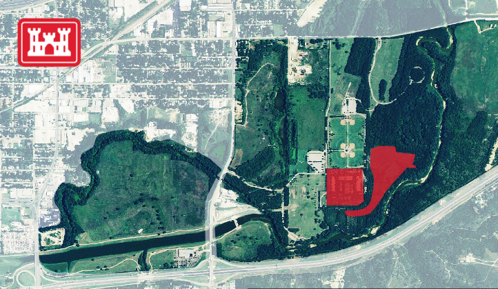
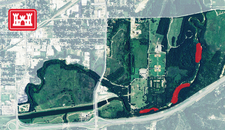
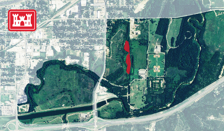
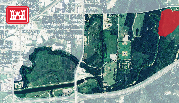
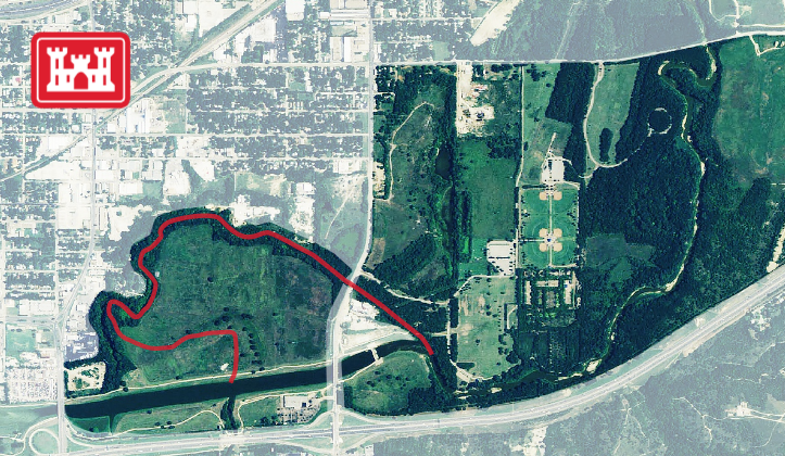
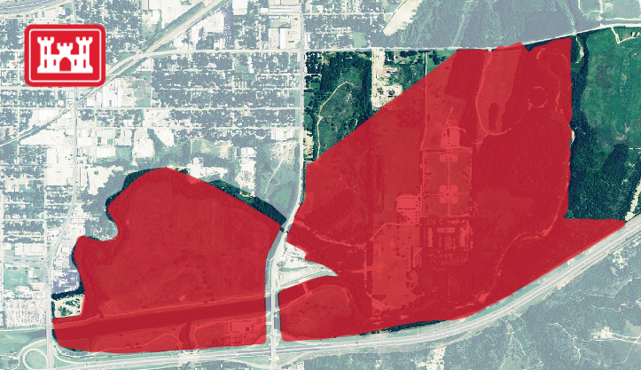
USACE FLOOD WATER STORAGE IN GATEWAY PARK

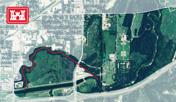
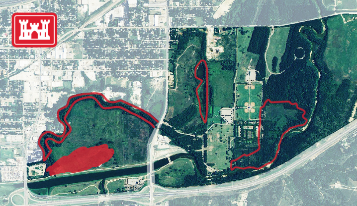
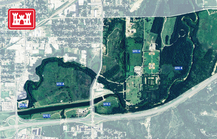
The future United States Army Corps of Engineers bypass channel will protect more than 2,400 acres of established neighborhoods in Fort Worth from the highest level of flooding. However, the USACE bypass channel cannot accomplish this alone. In times of flooding water will be moving through the future bypass channel but there has to be a way to slow that water down so we aren’t flooding our neighbors to the east. A series of flood water storage sites is crucial to the Central City Project.

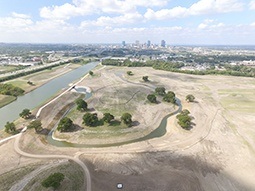
The amount of material moved as well as the locations themselves were carefully chosen. These flood water storage sites provide the needed flood protection but also provide multiple use opportunities. In many cases (Riverside Park and Gateway Park for example), USACE will excavate the valley storage site and then that area can be turned over to the City of Fort Worth to provide wonderful park amenities for our city.

Click here to see the City of Forth Worth’s plans for recreation in Gateway Park.

Ecosystem Restoration

OVERVIEW

When the existing levees were built in the 1950’s they severed an existing oxbow on the West Fork of the Trinity River just West of Beach St. in Gateway Park. As part of the flood water storage work in the area, there is also a significant restoration of the Riverside Oxbow Ecosystem. By restoring the original flow of the river in this area major ecosystem improvements will follow. These efforts include the plating of over 60,000 native oak and pecan trees, an aquatic habitat restoration effort and a wetland restoration supporting both aquatic and terrestrial wildlife species.

ENVIRONMENTAL REMEDIATION


The Riverside Wastewater Treatment Plant in Gateway Park was shut down in the mid-1970s by the Texas Commission on Environmental Quality due to environmental conditions leaving behind its ruins as seen in the photo.

In an effort to not allow any kind of contaminants from the decommissioned plant to reach the Trinity River the City of Fort Worth, in partnership with the Department of Defense, developed a program to clean up the wastewater plant site removing all potential hazardous material to a certified landfill. Upon completion this area will then be able to be fully utilized for creating wetlands, aquatic habitat, improved forested areas and recreational trails.

RIVERBANK STABILIZATION


To secure, maintain and preserve the only remaining natural section of the Trinity River in Fort Worth the City partnered with Texas Parks and Wildlife to stabilize the existing riverbank along this section of the Lower West Fork. This effort preserved this tranquil location and turned it into a coveted interpretive learning opportunity by adding sensitive public access trails and two beautiful scenic overlooks for viewing this special location.

WETLAND RESTORATION


The boundaries of the new Gateway Park Plan includes an area that was once used for removal of sand and gravel leaving behind pits from where that material was removed. This area will be restored and turned into a natural functioning wetland that will support both aquatic and terrestrial wildlife species. This wetland will include adjacent forested areas as well.

LAND RECLAMATION


The eastern portion of Gateway Park was once home to a large city landfill used for household refuge. As seen in the photo, the land remained vacant and under-utilized until the City of Fort Worth successfully worked out a smart plan with the Texas Commission on Environmental Quality to reclaim the property for recreational use.

The City then worked with USACE to secure the landfill site as a location to deposit 1.5 million cubic yards of dirt on top of the old landfill providing a very large cap. The large cap made the area prime for enhanced surface uses. The area is now being planned soccer fields, baseball diamonds and park amenities to serve the entire community.

RIVER RESTORATION


In the 1960’s the U.S. Army Corps of Engineers channelized the Trinity River in the area now known as Gateway Park. The channelization cut off a large section of the natural river leaving behind a large dry river oxbow. This oxbow became home to 200-year-old trees in distress and an area littered with ragweed and illegal dumping. As seen in the photo, the Gateway Park Plan has already returned the flow of the river to this old section of the Lower West Fork. Phase two will secure and maintain the area in and along the banks of this section to recreate the healthy natural river habitat environment that once existed in this neglected section.

EROSION CONTROL

Historically, most of Gateway Park floods every five to ten years. When flooded the park would remain under water for extended periods of time, as shown in the photo. This inundation pattern caused costly damage to recreational areas and serious erosion problems. The Gateway Park Project modifies the park to drain in a more efficient and predictable manner eliminating the damage to the surface thereby allowing greater opportunities for recreational and interpretive uses alike.

AQUATIC HABITAT RESTORATION


In response to the deadly 1949 flood, the United States Army Corps of Engineers channelized the Trinity River in Fort Worth which included the area now known as Gateway Park. This effort cut off a large section of the Trinity River in the park leaving behind a dry oxbow harming both the terrestrial and aquatic habitat.

The Gateway Park Plan restores the natural course of the river. As part of this aquatic habitat restoration effort, flow, oxygenated riffles and natural fish bunkers will be created in an effort to restore the natural aquatic habitat that once existed in this area.

REFORESTATION


In response to the 1949 flood, the USACE channelized a section of the Trinity River in the area now part of Gateway Park. As depicted in the photo, the channelization effort stripped the bottomland forest immediately north of the channel to depositing the dirt in this area. In an effort to restore the bottomland hardwood habitat that once existed along this section of the Trinity, the project will re-grade the surface elevation in the river bottom to return it back to an optimal elevation for bottomland hardwood conditions for a massive reforestation effort.

The invasive species will be removed and replaced with over 60,000 indigenous oaks and pecans which at one timed thrived in this area. This effort will recreate a natural bottomland forest to restore the natural habitat and support wildlife that would traditionally live there. In addition, interpretative trails with signage will be developed to increase public use and knowledge.

Central City Flood Control Project    >>

Project Resources & FAQs    >>